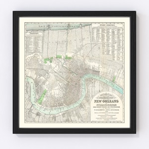

Old New Orleans Map Art Print, 1932, Archival Reproduction, Historic factory USGS Topographic Map, 16x20, Unframed
Archival print reproduction of an antique map of New Orleans from 1932 by the factory U.S. Geological Survey.
MEDIUM: Archival pigment inkjet print
PAPER: 100% cotton, museum quality, acid-free, heavyweight, matte finish
SIZE: 16x20 inches
Please note: frame is not included.
ABOUT THIS MAP
Historic USGS topographic map of New Orleans, Louisiana from 1932. The map covers the central portion of New Orleans, from the Mississippi River north to City Park, as well as the communities of Marrero, Harvey, and Gretna on the south side of the river. Shows numerous details, including roads, railroads, canals, ditches, marshes, and wooded areas. Also shows major buildings, including schools, churches, government buildings, and hospitals.
Browse all NEW ORLEANS maps in our shop:
https://www.etsy.com/sg-en/shop/BlueMonocleMaps?search_query=new+orleans
Browse all US CITY maps in our shop:
https://www.etsy.com/sg-en/shop/BlueMonocleMaps?section_id=11234782
Browse ALL prints in our shop:
https://www.etsy.com/shop/BlueMonocleMaps